Important Plant Areas by Carol Ralph
California is losing biodiversity now. Mapping the plant places we most need to save is urgent and crucial to the conservation of California's botanical heritage. State CNPS is building the first comprehensive map of these Important Plant Areas (IPAs). The criteria include measures of rare plants, rare natural communities, plant diversity, soils, ethnobotanical importance, and other botanically significant traits. The project collects data from a multitude of sources, such as herbaria, rare plant records, and personal lists, into an arcGIS map with many "layers" for the different criteria. The data then goes into a mathematical model producing a "heat map" of the area, with higher conservation value shown in warmer colors. People planning developments, like wind farms or cannabis farms, can avoid areas of high conservation value. Land managers, like the U.S. Forest Service, State Parks, or land trusts, will see places they need to conserve and maintain, for example with weeding, grazing, or burning. Watchdog organizations and citizens will see the same information.
The value of this map depends on us telling the model about places like the rich, old growth stand at Groves Prairie, the spectacular lupines on Bald Hills Rd., and the genetically diverse Western Azaleas on Stagecoach Hill. If you can contribute or help enter observations, please contact Tony (This email address is being protected from spambots. You need JavaScript enabled to view it.). Find out more at https://www.cnps.org/conservation/important-plant-areas
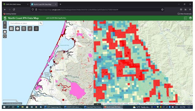 Screenshot of the arcGIS map showing data entered (left) and conservation values (right) from Humboldt Bay to Forest Highway 1. In arcGIS, the vertical bar moves left-right to show either format.